
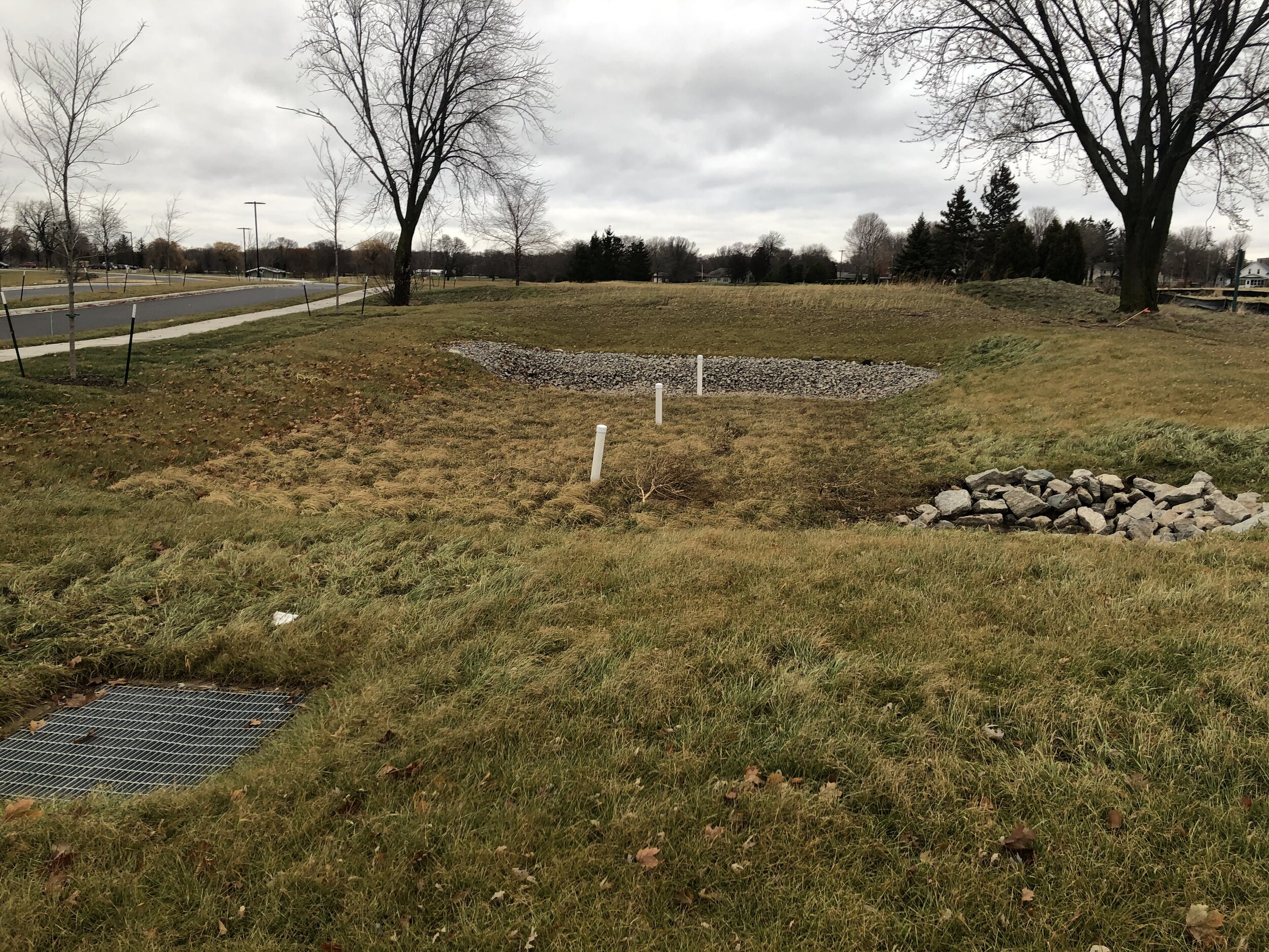
Monitoring the Performance of a Subsurface Gravel Wetland
Subsurface gravel wetlands are an emerging green infrastructure practice that treat stormwater by passing flow through a subsurface gravel media. They are gaining in popularity due to several factors including their small hydraulic head requirement, easy placement within the footprint of stormwater ponds, and potential for water quality benefits. However, to date there is limited monitoring research on the performance of these systems. This study seeks to fill this gap through flow and water quality monitoring of a subsurface gravel wetland in Oshkosh, WI. The outcomes of this study will help inform Wisconsin municipalities and stormwater regulators as they consider developing technical standards for subsurface gravel wetlands and seek to understand their potential for addressing Total Maximum Daily Loads (TMDLs).
Publications:
Sullivan, C., McDonald, W.M., 2022. Hydrologic and water quality performance of a subsurface gravel wetland treating stormwater runoff. Journal of Environmental Management. Accepted.
Supported by:

Understanding the Impact of Green Infrastructure on Infiltration and Inflow at a Sewershed Scale
Green infrastructure (GI) is an effective stormwater management tool for reducing volume and improving water quality of runoff from residential properties. However, the unintended consequences of GI on residential properties, such as private property infiltration and inflow (PPI/I), remains largely unknown. To that end, the primary question surrounding GI and PPI/I is whether concentrating and infiltrating runoff from impervious surfaces will subsequently increase PPI/I through leaky laterals on site. This project will result in a sewershed scale modeling tool and case study application that evaluates how residential hydrology, such as the capture and infiltration of runoff, influences PPI/I.
Publications:
Sebo, S., McDonald, W.M., 2022. Impact of Sewershed Characteristics on Rainfall Derived Inflow and Infiltration. Journal of American Water Resources Association. DOI: 10.1111/1752-1688.13051 [Link]
Supported by:
Evaluating Green Infrastructure Performance through Continuous Monitoring
Across the U.S. cities are looking to green infrastructure to address the threat of increasing precipitation and its associated challenges. This is a prudent investment, as green infrastructure is a resilient and adaptable solution to meeting runoff goals in the face of uncertainty; however, there exists a knowledge gap between engineering designs and validation of performance through long-term monitoring. Without accurate and reliable benchmarking of green infrastructure performance, green infrastructure investments may be misappropriated to under- or over-performing practices.
Therefore, in this project we are monitoring the flow rate through two green infrastructure practices in Milwaukee, WI to quantify the variability of volume retention and peak flow mitigation, define the factors that contribute to this variability, and ultimately develop improved metrics for volume retention and peak flow rates in green infrastructure. This project will produce actionable results to guide strategic green infrastructure investments for meeting the MMSD's stormwater goals of zero sewer overflows, zero basement backups, and improved stormwater management.
Publications:
Regier, E.M., McDonald, W.M., 2022. Water quality and hydrologic performance of two bioswales at an urban farm. Journal of Sustainable Water in the Built Environment. 8(3). [Link]
Supported by:
Milwaukee Metropolitan Sewerage District

Low-Cost Active Controls to Improve Volume and Peak Flow Mitigation of Green Infrastructure
Many metropolitan areas are investing heavily in green infrastructure to mitigate flood risks by managing stormwater where it falls. Green infrastructure is an adaptable and resilient approach to managing stormwater; however, current designs are underutilized. Green infrastructure practices contain volumetric storage in pore spaces that could be fully captured if controlled as an active system. Therefore, in this project we are developing a low-cost active control system that can augment green infrastructure practices to improve volume and peak flow mitigation. This active control system will be applied and monitored in a pilot green infrastructure practice to demonstrate performance in the field. In addition, monitoring data will be used to develop models that can be applied within engineering design to accurately attribute volume capture and peak flow mitigation to the proposed active controls.
Supported by:
GHR Foundation Seed Grant, OPUS College of Engineering, Marquette University
NSF I-Corps

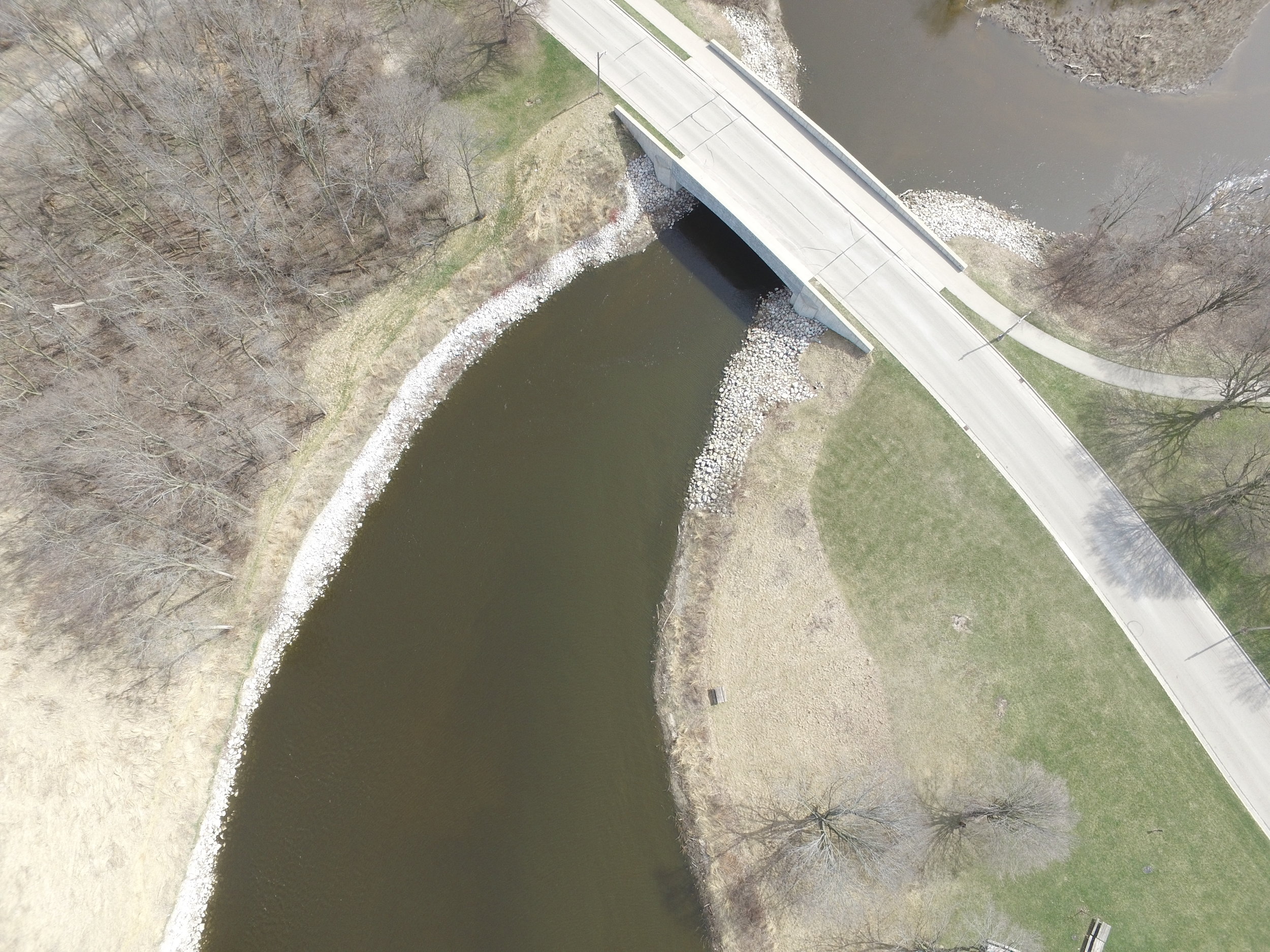
Aerial Imaging Riverflow System (AIRS): Measuring Flood Peaks using Drones
Extreme precipitation events in the U.S. cause billions of dollars in infrastructure damages and hundreds of lives to be lost each year. Engineering solutions to these disasters require accurate and reliable streamflow data that capture the magnitude of flood conditions. However, flow rate measurements during floods are inherently uncertain, and physical measurements of velocity during flood conditions are prohibitive in many cases. Therefore, novel methods to measure stream velocity during extreme floods must be considered. This project addresses this challenge through the development of the Aerial Imaging River System (AIRS), a novel system that utilizes drones, video imaging, and object-tracking algorithms to measure velocity in streams during extreme floods. If realized, this system could represent a breakthrough technology that transforms the way that extreme floods are measured.
Publications:
Jyoti, J., Sebo, S., Medeiros, H., McDonald, W.M., 2020. Remote sensing of river velocity using drone video and optical flow algorithm. EWRI World Environmental & Water Resources Congress, May 17-21, 2020, Henderson, NV. [Link]
Supported by:


Model development for design and real-time control of stormwater basins for watershed management during climate change adaptation
Real-time control (RTC) of stormwater basins has been implemented successfully to meet water quantity and quality criteria in the past, but new challenges are emerging. To-date, basin sizing and RTC rule selection methods have failed to incorporate climate variability and internal basin dynamics (i.e, outflow and pollutant removal). This project integrates a novel methodology to integrate both into a model to size basins and define optimal control rules.
Publications:
Sharior S., McDonald, W.M., and Parolari, A.J. 2019. Improved reliability of stormwater detention basin performance through water quality data-informed real-time control. Journal of Hydrology. [Link]
Supported by:
Earl B. and Charlotte Nelson Award, Opus College of Engineering, Marquette University


Heat Orthoimagery Terrain Temperature Water (HOTT Water) Model
Temperature represents one of the largest impairments for rivers and streams across the United States, and is projected to get worse as land development and climate change accelerate thermal stress on aquatic environments. Solutions will require accurate and reliable models that represent rainfall-runoff temperature dynamics – particularly the characterization of terrain or land surface temperatures. However, existing empirical terrain temperature models are limited by the point-based data they are built upon, and limited studies have considered the high-resolution spatial distribution of temperature across homogenous land surfaces, which are known to be significant. This project therefore seeks to fill this knowledge gap by using a drone to collect high-resolution thermal orthoimagery and applying the data to develop an empirical terrain temperature model. This represents the first phase in development of the Heat Orthoimagery Terrain Temperature Water (HOTT Water) model, a novel comprehensive watershed temperature tool. Experimental sites include Marquette University and the University of Texas El Paso, providing two distinct geomorphologic and climatic regions for model development.
Publications:
Naughton, J.B., McDonald, W.M., 2019. Evaluating the variability of urban land surface temperatures using drone observations. Remote Sensing. [Link]
Supported by:

Pilot experiments to integrate water quality data streams into real-time control of green infrastructure
Real-time control (RTC) of stormwater basins has been implemented successfully to meet water quantity and quality criteria. However, no existing RTC systems leverage real-time water quality data for outflow control. Previous research has demonstrated the value of simultaneous water quantity and quality control using simulation models. This project extends previous theoretical and modeling work to a real-world pilot demonstration RTC site.
Publications:
Sharior S., McDonald, W.M., and Parolari, A.J. 2019. Improved reliability of stormwater detention basin performance through water quality data-informed real-time control. Journal of Hydrology. [Link]
Supported by:
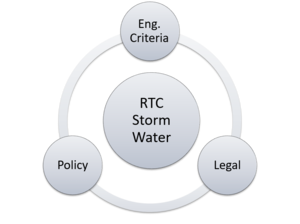
Evaluating and proposing engineering, policy, and legal options to guide real-time control of stormwater infrastructure
Real-time control (RTC) of stormwater infrastructure has been proven to be an effective measure for urban stormwater management. However, applications have been limited due to a lack of engineering, policy, and legal readiness for breakthrough technologies. This project will therefore address this gap to accelerate a technology that has the potential to transform urban stormwater management. The proposed project plan involves 4 tasks:
Review the current state of the practice in stormwater engineering design criteria and identify those that address RTC of stormwater infrastructure.
Evaluate engineering design criteria alternatives that consider RTC of stormwater infrastructure through hydrologic models.
Identify institutional and legal barriers and incentives to implementation of RTC.
Develop a framework that incorporates engineering, policy, and legal options for advancement of RTC of stormwater infrastructure.
This project will result in engineering, policy, and legal options that stakeholders can use to implement RTC of stormwater infrastructure.
Publications:
Strifling, D., McDonald, W.M, Hathaway, H. and Naughton, J.B., 2019., Overcoming Legal and Institutional Barriers to the Implementation of Innovative Environmental Technologies (October 23, 2019). Notre Dame Journal on Emerging Technologies (Forthcoming). [Link] [PDF]
Naughton, J., Sharior, S., Parolari, A., Strifling, D., & McDonald, W. (2021). Barriers to Real-Time Control of Stormwater Systems. Journal of Sustainable Water in the Built Environment, 7(4), 04021016. [Link] [PDF]
